
At some point in the 1660s, a document was signed. The Rappahannock tribe handed over a large tract of Virginia riverland in exchange for a reported payment of blankets. Thirty blankets. The transaction was recorded, filed away, and mostly forgotten at least by the people who benefited from it.
The Rappahannock people did not forget.
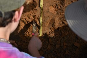
And recently, archaeologists working along the Rappahannock River gave that memory something it hadn’t had in centuries: physical proof. Working along the bluffs above Virginia’s Rappahannock River at a place called Fones Cliffs, the team excavated thousands of artifacts across two sites beads, painted pottery shards, stone tools, tobacco pipes, some of them dating to the pre-contact era. The findings were reported in Archaeology Magazine..
Here’s what makes this more than a routine dig: the sites correspond almost exactly to villages that Captain John Smith sketched onto a map in 1608. Smith had charted multiple Rappahannock villages along the river’s northern banks, including several fortified towns he named on his map, all of them perched atop Fones Cliffs. His journal recorded a hostile encounter with warriors near those bluffs. He survived. He drew the map anyway. And for more than 400 years, that map sat in the historical record like a quiet promise waiting to be redeemed.
The Territory That Disappeared on Paper

At their peak before European contact, the Rappahannock controlled a substantial territory along the Rappahannock River and supported a population of several thousand people. They were not a small community living lightly on the land. They built fortified towns on high bluffs. They cultivated the river. They had warriors disciplined enough to stand still in the brush while an English boat passed beneath them.
Within a century of European contact, that world had largely been dismantled, through disease, displacement, and transactions like the one recorded in the 1660s. Twenty-five thousand acres for 30 blankets. By any reasonable measure, that exchange was not an exchange. But it was documented. And documentation, in colonial land law, became ownership.
The tribe today numbers in the hundreds of members. They have so far reclaimed a portion of their ancestral land, working alongside the U.S. Fish and Wildlife Service to protect the excavation sites at Fones Cliffs. Two thousand one hundred acres, against a historical claim of 350,000. The math is uncomfortable. But the direction of travel has changed.
What 11,000 Objects Prove
It is worth pausing on what these artifacts actually do, not just for archaeology, but for the Rappahannock tribe’s ongoing land claim.
Oral traditions have long placed Rappahannock villages on those bluffs. Smith’s map placed them there too. But oral history has a habit of being dismissed in legal and governmental proceedings, and a 400-year-old colonial map drawn by an Englishman who was actively being ambushed at the time carries its own limitations as documentary evidence.
What 11,000 physical objects do is different. Beads and pottery shards and tobacco pipes pulled from the earth at the precise coordinates Smith recorded, those speak a language that land-rights negotiations understand.
The tribe has used the site’s cultural significance as part of its argument for reclamation. And now the ground itself has answered back.
How strange it is, when you sit with it, that the very map drawn by the man whose arrival set colonial dispossession in motion became the instrument that helped recover a piece of what was lost.
A Map, a Memory, and 30 Blankets

There is a particular kind of historical recovery happening at Fones Cliffs, one that doesn’t fit neatly into the usual story of archaeology as a purely academic exercise. The researchers from St. Mary’s College weren’t just confirming a footnote in Captain John Smith’s journals. They were handing the Rappahannock tribe something usable. Something that connects the painted pottery from the 1500s to the land dispute of the 2020s in a single unbroken line.
The artifacts will be studied. Some will likely be repatriated. The sites at Fones Cliffs are now under active protection. And the 300 members of the Rappahannock tribe, the descendants of those 2,400 people who once controlled 350,000 acres of Virginia riverland, are still at the table, still making the case, still using every available tool to close a gap that 30 blankets opened more than three centuries ago.
The map held the memory. The ground held the proof. What happens next is a question that belongs to the living.
This article was researched, written, and edited by our human editorial team. AI tools were used in a limited research-assistant capacity. All claims were independently verified.


